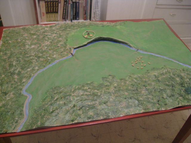
 The blue is the Great River Ouse (in England). The cliff is where my Baron's Keep will be. (That little wheel-looking thing there is actually the curtain-wall around the Keep and 2 other large buildings. The tiny things that look like sheep are actually the cottages of the village of Woadsbury. The landscape is taken directly from Google Earth (there is actually a bend in the Great River Ouse just like this at 52° 01' 39.74" N and 0° 52' 52.43" W.) The cliff and the forest are pure invention, as is the village and name of Woadsbury. But my Ed actually lived along the Ouse (pronounced Ooze) for several years!
  This is the view from the edge of the cliff looking down on the bridge and the village. I didn't spend much time on the cottages - I really just want them for placement so that I can decide who lives where and what they do. As I develop my story, I'll be adding stone walls to contain sheep and goats, further defining each cottage's "yard" and putting in small gardens. I'll put in trees, too, of course, in scale so that I can determine "views" from various vantage points. I had intended to put in painted Q-tip "trees" for the whole forest to give it the 3D effect I wanted (yes, serious overkill! That would have been thousands of trees!), but our story covers several thousand years and the forest will disappear over time. I didn't want to limit my model to only MY story - so my solution is to cut material to lay over the open areas, painting it to show what the landscape looks like in each different time. It'll be rather like playing paper dolls with the landscape! :)
 There are two bridges over the river, the one above services the roads that lead to the NW (towards Segontium in my story's time, and Liverpool today) and to the SW towards Winchester and Somerset).
This second bridge services the roads leading NE towards Cambridge and SE towards London.
Our little village has a thriving woad industry, thus the name Woadsbury. (Woad is similar to henna, coming from a plant and used to dye the skin - only henna is a reddish/brown/black hue and woad is a lovely blue color.) This industry produces goods dyed with the lovely woad and in demand all over England in the time of my story in 500 AD. This third picture shows where the road drops right into the trees from the bridge, but it doesn't show how. Hopefully, I'll get the 3D forest overlay done soon. That will really make this effective! I plan to use batting (for depth) but that will be rather difficult to paint. Of course, I supposed I could make it a winter scene! LOL
Anyway - there are the first pictures of it so far. It has already proven invaluable in working out many details for my story and for Ed's. The group seems to really like it, too. We'll be carting it back and forth to all of our Writer's Group Meetings because it's just too helpful in working out the early details as we weave our many different stories into one glorious whole!
My Baron Woadsbury is the founder of the line, receiving his title and lands from Arthur himself. I'm having so much fun writing it!
Your village reminds me of Ken Follet's Pillars of the Earth. It depicts 10th century England during the reign of Queen Maude.
ReplyDeleteIt also makes me think of Three Pines, a fictional village in Quebec, created by Louise Penny, who wrote a series of mystery novels set in the village and investigated by Chief Inspector Gamache. They were delightful.
cool, good ideas
ReplyDelete